
TUESDAY 12 September 2023
Location: Zoom, 7:00 PM ET/6:00 PM CT/ 5:00 PM MT/4:00 PM PT
(Arranged with the assistance of the Rocky Mountain and Texas Map Societies; sponsored in partnership with California, Chicago, New York, Philip Lee Phillips, Rocky Mountain, and Texas Map Societies)
Title: The Role of Maps in Films about Exploration and Discovery: Some Latin American Examples
Speaker: Richard Francaviglia, Professor Emeritus, University of Texas at Arlington; currently Associated Scholar, Willamette University, Salem, Oregon
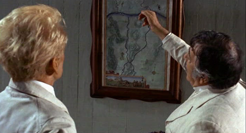
Summary: Filmmakers have long used maps on screen to chart the progress of characters going from one place to another — for example, explorers taking a ship from the Old World to the New. However, cinematically speaking, maps serve many other purposes as well. In this presentation, I will discuss the varied ways that films depicting the process of exploration and discovery in South America employ maps. These include: 1) indicating the location of sought-after geographical features (e.g., lost cities); 2) establishing or authenticating the time period of events; 3) identifying the current political situation by showing boundaries between nation-states; 4) depicting the state of Indigenous and scientific knowledge about places; and 5) stylistically symbolizing the geographical locale metaphorically (e.g. depicting the Amazon River as a serpent). Some of the maps in these films are authentic, but many are artistic creations. Noteworthy films discussed and deconstructed in this presentation range from: A) docu-dramas depicting actual explorations (e.g. Aire Libre which portrays the Humboldt/Bonpland explorations of Venezuela ca. 1800; The Lost City of Z; and Embrace of the Serpent); B) imaginatively embellished accounts of actual explorations (e.g. Fitzcarraldo; The Mission); and C) wildly fictionalized but entertaining adventure films (e.g., Jungle Cruise and Dora and the Lost City of Gold). Although some films use maps almost incidentally in a scene or two, in other films they appear throughout and become an integral part of the plot; the latter include The Motorcycle Diaries and Indiana Jones and the Kingdom of the Crystal Skull. As this presentation makes clear, filmmakers not only visually romanticize the majestic landscapes of South America, but also cartographically brand portions of the continent to authenticate the experiences of these cinematic explorers.
Bio: Historical geographer Richard Francaviglia has had a life-long interest in maps. His first job
after graduating from high school was at Rand McNally Co. (San Francisco, 1961), and he has studied and created maps throughout his varied forty-five year long career. He retired as
Director of the Cartographic History Center (University of Texas at Arlington, 2008), but remains an active researcher and lecturer. His most recent book — Cinematic Journeys in Latin
America: Geography through the Lens of Exploration and Discovery Films — is scheduled for
publication in 2023.
You are invited to a Zoom meeting.
When: Sep 12, 2023 07:00 PM Eastern Time (US and Canada)
Register in advance for this meeting:
https://us06web.zoom.us/meeting/register/tZArd-qhqD8jHdwGaXClrVQVX9ImaMd75gf- (note the “-” after the final f)
After registering, you will receive a confirmation email containing information about joining the meeting.